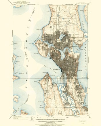
City of Seattle, 1908


Seattle, 1908

Every once in a while, here at Spatialities world headquarters, our research department (me) runs into an old archived map that our marketing department (also me) thinks would look great on someone’s wall.

I found this 1908 USGS quad while researching the former location of the Lake Washington shoreline. It’s from an important time in Seattle’s history. The the Alaska Yukon Pacific Exposition was about to happen, which would shape the University of Washington campus for the next century and beyond. Because the Ship Canal had not been built, Lake Washington was eight feet higher.  The Duwamish River still meandered, and South Park and Georgetown were towns in their own right. People were still waiting for the interurban. Rail travel within and between cities was still the best way to get around. Freeways hadn’t been invented.

I did a considerable amount of clean-up to this map–removing old rubber-stamps and imperfections.  It’s now ready for your wall.

You can order hard-copy prints of the files I’ve cleaned up here…

1908 Map of Seattle--Archival Paper Print
1908 Map of Seattle–Archival Paper Print
1908 Map of Seattle--Wrapped Canvas
1908 Map of Seattle–Wrapped Canvas


Continue reading

Planning for Safe Routes to School

The McDonald International School re-opened in 2012, after 31 years of being mothballed and leased out to various NGOs. Even though the school is in a very walkable neighbSRTS_CoverPageorhood, having been built in what was originally a streetcar suburb of Seattle, little attention had been paid to the walkability of the immediate school area. The streets around the school need a lot of work to make them safer for all kids, their parents and caretakers.

As a final project for my Sustainable Transportation certificate, I researched and wrote up a plan to create safe routes for the McDonald International School. This plan deals primarily with the physical environment within the school reference area, but also touches on some of the social and cultural aspects of walkable cities. This was my first project dealing with active transportation issues, and led to my involvement with a variety of other bike & pedestrian advocacy organizations, including the Seattle Ped Board and Seattle Neighborhood Greenways.

McDonald School SRTS Plan

A Transportation Plan for Wallingford, Seattle

Wallingford is my neighborhood. I’ve lived here for over ten years, commuting out to Redmond for the first year via scooter and bus. After that, I started working at the University of Washington, with an exact mile commute, door-to-door. I still take my ratty old scooter, but I’ll just as often walk, bike, or bus.

Wallingford Transportation Plan
Wallingford Transportation Plan, Phase III

For those of us who work at the UW, Wallingford is in an ideal location–easily walkable, if you don’t mind traversing I-5 and its associated on and off-ramps. You can quickly bike there if you don’t mind the cranky and sometimes aggressive car commuters. The bus is great, except for the winding, plodding 16 and the always-late, always SRO-packed 44. In addition to these indignities to the non-car commuter, Wallingford is more isolated, transportation-wise, than its U-District and Fremont neighbors. This paper, which I co-wrote with two other authors, creates a plan to remedy these problems. It deals with both land-use and transportation issues, which should always be planned in concert, but sadly often aren’t. We focused on enhancing connections to neighboring communities, as well as to downtown Seattle, decreasing the isolation of the neighborhood and allowing for a more compact and energetic local business district. My contributions were the introduction, land-use, rail, and summary chapters.

Wallingford Transportation Plan